But really, what more do you need? Switzerland. Tall, snow-peaked mountains, with the black and white photograph making them look even colder. Some pines in the foreground, and the hint of a village on a slope. So peaceful.
עוד גלויה במסגרת המקומות הרחוקים והקרים, אבל הפעם אין הרבה פרטים, אז הרשומה הזו תהיה די קצרה.
אבל מה עוד צריך, בעצם? שווייץ. הרים גבוהים ועטויי שלג, שבגלל הצילום בשחור-לבן נראים צוננים עוד יותר. כמה אורנים בקדמת התמונה, ורמז של כפר על המדרון ממול. איזו שלווה.
אבל מה עוד צריך, בעצם? שווייץ. הרים גבוהים ועטויי שלג, שבגלל הצילום בשחור-לבן נראים צוננים עוד יותר. כמה אורנים בקדמת התמונה, ורמז של כפר על המדרון ממול. איזו שלווה.
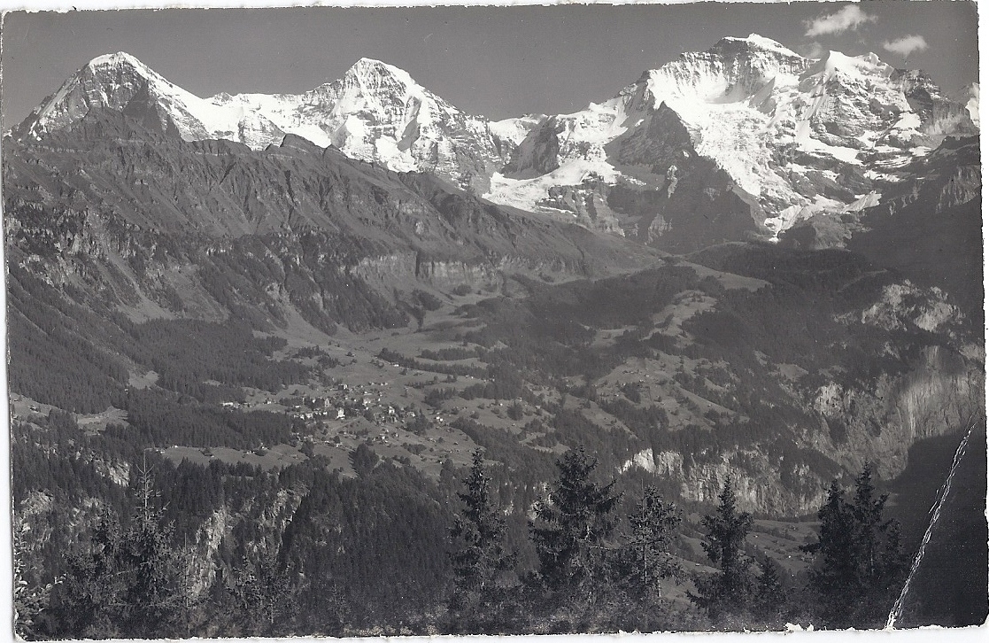
There is no message written on the back, just the description: Eiger, Mönch, Jungfrau. Wengen von Sulwald ob Isenfluh.
Since out of these eight words six are place names, it wasn't too hard to figure this out: Eiger, Mönch and Jungfrau are the names of the mountain peaks; the second part explains that the village in the picture is Wengen, and that we are watching it from Sulwald or Isenfluh, which are two other places that are quite close to each other (okay, I am actually not 100% sure that I correctly interpreted that 'ob', so any German-readers who end up here are welcome to correct me, but it seems to make sense).
אין הודעה מאחורה, רק התיאור: Eiger, Mönch, Jungfrau. Wengen von Sulwald ob Isenfluh.
מכיוון שמתוך שמונה המלים האלה שש הן שמות מקומות, לא היה קשה לפענח את הכיתוב. אייגר, מונך ויונגפראו הם שמות הפסגות; החלק השני מסביר שהכפר הוא וונגן, ושאנחנו צופים בו מסולוולד או איזנפלו, שהם עוד שני מקומות שסמוכים זה לזה (טוב, אז אני לא בטוחה ב-100% שבאמת פירשתי נכונה את ה-'ob' הזה, אז אם מזדמנים לכאן קוראי גרמנית אשמח לתיקון, אבל זה נשמע לי הגיוני בכל אופן).
מכיוון שמתוך שמונה המלים האלה שש הן שמות מקומות, לא היה קשה לפענח את הכיתוב. אייגר, מונך ויונגפראו הם שמות הפסגות; החלק השני מסביר שהכפר הוא וונגן, ושאנחנו צופים בו מסולוולד או איזנפלו, שהם עוד שני מקומות שסמוכים זה לזה (טוב, אז אני לא בטוחה ב-100% שבאמת פירשתי נכונה את ה-'ob' הזה, אז אם מזדמנים לכאן קוראי גרמנית אשמח לתיקון, אבל זה נשמע לי הגיוני בכל אופן).
And one nice thing to finish with - thanks to the wonders of technology, you can now find the relevant places on Google Earth, and recreate the photo almost exactly. I'm putting a link this time, rather than embedding, both because it requires a plug-in for Google Maps that not everyone might be interested in, and because the embedded version makes everything run slow. But here, have a look. It's cool.
ומשהו אחד נחמד לסיום - בזכות פלאי הטכנולוגיה, אפשר למצוא ב-Google Earth את המקומות הנזכרים, ולשחזר את התמונה כמעט במדויק. אני מקשרת הפעם, ולא מטמיעה, גם כי זה דורש התקנה של פלאג-אין בשביל גוגל מפות, שאולי לא כולם מעונינים בו, וגם כי זה מאט מאוד את הגלישה. אבל הנה, תסתכלו. זה מגניב.
Update: Got a correction of the German from Peter, who explains: "'ob' by the way is old German for 'oberhalb' = upon or above, so Isenfluh may be a river or village below Sulwald". And since Sulwald is indeed a bit above the village of Isenfluh, it all makes sense now. Thank you!
עדכון: קיבלתי תיקון לגרמנית מפטר, שמסביר ש-ob הוא צורה ארכאית של oberhalb, 'מעל'. ומכיוון שסולוולד אכן נמצא קצת מעל הכפר איזנפלו, הכל הרבה יותר הגיוני עכשיו. תודה!
This comment has been removed by a blog administrator.
ReplyDeleteשלום. מחקתי את התגובה שלך מחשד לספאם. אם טעיתי, את מוזמנת לכתוב אותה מחדש, בלי הלינק לאתר שלא קשור בגרוש לתוכן הבלוג.
Delete